The Los Angeles Aqueduct is Wild
Practical Engineering
0:01 On the northern edge of Los Angeles,
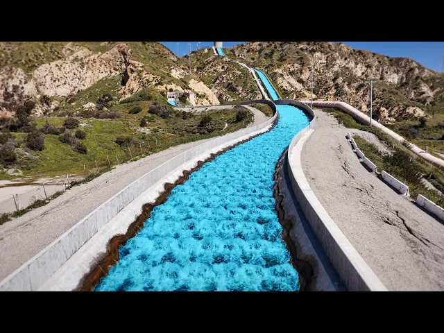
0:04 fresh water spills down two stark concrete chutes
0:07 perched on the foothills of the San Gabriel Mountains,
0:10 a place simply called The Cascades.
0:13 It’s a deceptively simple-looking finish line:
0:15 the end of a roughly 300-mile (or 500 km) journey
0:20 from the eastern slopes of the Sierra Nevada into the city.
0:24 On November 5, 1913,
0:26 tens of thousands of people climbed these hills to watch the first water arrive.
0:31 When the gates finally opened, water trickled through,
0:35 but that trickle quickly became a torrent.
0:37 The project’s chief engineer, William Mulholland,
0:40 leaned over to the mayor and shouted the line
0:44 that’s been repeated ever since: “There it is, Mr.
0:47 Mayor.
0:47 Take it!” That moment was profound for a lot of reasons,
0:51 depending on where you live and how you feel about water rights.
0:55 LA didn’t become LA by living within the limits of its local resources.
0:59 Its meteoric growth into the metropolis we
1:03 know was enabled by an early and extraordinary
1:06 decision to reach far beyond its own watershed
1:10 and pull a whole new river into town.
1:13 Today, roughly a third of LA’s water comes
1:15 from the Eastern Sierra through the Los Angeles Aqueduct system.
1:19 That share swings with snowpack, drought, and environmental constraints,
1:24 but this one piece of infrastructure helped
1:27 turn a water-limited town into a world city.
1:30 It’s one of the most impressive
1:33 and controversial engineering projects in American history.
1:36 But to really appreciate that water in the cascades,
1:39 you have to look way upstream and see what it took to get it there.
1:46 It’s gravity, geology, politics,
1:47 and human ambition all in a part of the state that most people never see.
1:52 Let’s take a little tour so you can see what I mean.
1:56 I’m Grady and this is Practical Engineering.
2:08 When most people think about aqueducts, this is what they picture:
2:13 a bridge carrying water over a valley or river.
2:16 And, just to be clear, these are aqueducts.
2:19 But engineers often use the term more broadly to describe any type of conveyance
2:24 system that carries water over a long
2:27 distance from a source to a distribution point.
2:30 Could be a canal, a pipe, a tunnel, or even just a ditch.
2:35 In the case of the LA aqueduct, it’s all of them,
2:38 plus a lot of supporting infrastructure as well.
2:41 From the center of the city,
2:43 it’s about a four hour drive to the Owens River Diversion Weir.
2:47 It’s not accessible to the public,
2:49 but it is the official start of the LA Aqueduct,
2:52 at least when it was originally built.
2:54 Here, all the snowmelt and rain from a huge drainage system between
2:58 the Sierra Nevada and Inyo Mountains funnel down into the Owens River,
3:03 where a large concrete diversion weir peels nearly all
3:06 of it out of its natural course and into a canal.
3:10 This point is roughly 2,500 feet (or 750 meters) higher
3:14 in elevation than the bottom of the Cascades at the downstream end,
3:19 which makes it obvious why LA chose it as a source.
3:23 The entire aqueduct is a gravity machine.
3:26 There are no pumps pushing the water toward the city.
3:29 Half a mile of elevation change feels like a lot until
3:33 you realize you have to spread it out over 300 miles.
3:37 It’s all achieved through careful grading and managing
3:39 elevations along the way to keep the flow moving.
3:42 That care is particularly important in this upper section of the aqueduct,
3:47 where the water flows in an open canal.
3:50 To do this efficiently,
3:51 you need a relatively constant slope from start to finish.
3:54 That’s a tough thing to achieve on the surface of a bumpy earth.
3:59 Following a river valley makes this easier,
4:01 but you can see the twists and turns necessary
4:04 to keep the aqueduct on its gentle slope toward LA.
4:08 If it seems kind of wild that a city would buy
4:11 up the land and water rights from somewhere so far away,
4:14 it did to a lot of the people who lived in the Owens Valley, too.
4:18 A lot of the acquisitions and politics of the original
4:21 LA Aqueduct were carried out in bad faith,
4:25 souring relationships with landowners, ranchers,
4:27 farmers, and communities in the area.
4:30 The saga is full of broken promises and shady dealings.
4:34 Then when the diversion started, the area dried up,
4:38 disrupting the ecology of the region,
4:40 making agriculture more difficult and residents even more resentful.
4:46 Many resorted to violence, not against people but against the infrastructure.
4:50 They vandalized parts of the aqueduct,
4:53 a conflict that later became known as the California Water Wars.
4:57 In one case in 1924, ranchers used dynamite to blow up a part of the canal.
5:03 Later that year, they seized the Alabama Gates.
5:06 About 20 miles or 35 kilometers downstream from the diversion weir,
5:10 a set of gates sits on the eastern bank of the aqueduct canal.
5:14 Because it runs beside the river valley,
5:16 the aqueduct captures some of the water that flows down from the surrounding
5:20 mountains in addition to what’s diverted out of the Owens River,
5:24 particularly during strong storms.
5:26 That means it’s actually possible for the canal to overfill.
5:30 The Alabama Gates serve as a spillway,
5:33 allowing operators to divert water back down to the river.
5:37 This also helps drain the canal for maintenance or repairs when needed.
5:41 Those Owens Valley ranchers understood
5:43 exactly what the Alabama Gates controlled.
5:46 Open them, and the water would run back where it had always run,
5:50 down the Owens River, instead of south to Los Angeles.
5:54 The resistance simmered and flared for years,
5:56 but it didn’t end in the dramatic showdown at the aqueduct.
6:00 Instead, it ended at a bank counter.
6:02 The Inyo County Bank was run by two brothers who
6:06 were also key organizers and financiers of the resistance campaign.
6:10 In August 1927, an audit revealed major shortfalls and ongoing embezzlement,
6:17 and the bank quickly collapsed.
6:19 Residents across the valley saw their savings wiped out or frozen overnight,
6:24 shattering what was left of the community’s ability to keep fighting.
6:29 The Alabama Gates weren’t just a political flashpoint though.
6:32 They also marked an important dividing line in the aqueduct’s design.
6:36 LA knew that even if the ranchers didn’t
6:39 release the water to the river in protests,
6:42 a lot of it would end up there anyway through seepage.
6:45 As the canal climbed away from the valley floor and crossed more porous soil,
6:50 it would naturally lose its water through the ground.
6:53 So, at the Alabama Gates,
6:55 the aqueduct transitions from an unlined canal to a concrete-lined channel.
6:59 It’s still open to the air,
7:02 so there’s no protection against evaporation or contamination,
7:05 but the losses to the ground are a lot less.
7:09 This design continues for about 35 miles (or 55 kilometers) through the valley.
7:14 Along the way, the aqueduct passes the remains of Owens Lake.
7:19 Once a large body of water,
7:21 it quickly dried up with the diversion of the Owens River.
7:25 Of course, there were impacts to wildlife from the loss of water,
7:28 but the bigger problem came later: dust.
7:33 All the fine sediment that settled on the lakebed over
7:36 thousands of years was now exposed to the hot desert sun.
7:39 When the wind picked up,
7:41 it filled the air with fine particulates that are dangerous to breathe.
7:44 Over the years, there have been times when Owens Lake is
7:48 the single largest source of dust pollution in the entire country,
7:51 and LA has spent more than a billion
7:54 dollars just trying to fix this problem alone.
7:56 The aqueduct passing along the hillside past the lake
8:00 and its challenges is a reminder that the true cost of water is often a lot more
8:06 than the infrastructure it takes to deliver it.
8:08 So far, it might be obvious that this aqueduct system is pretty fragile
8:13 to be making up a major part of a city’s fresh water supply.
8:18 Even beyond the vandalism and political resistance,
8:21 there are a lot of things that could go wrong along the way,
8:24 from bank collapses, earthquakes, diversion failures, and more.
8:27 That’s why Haiwee Reservoir was originally built in a narrow
8:32 saddle between two hills as a kind of buffer.
8:35 With a dam on either side, it stored water up so the aqueduct
8:39 could keep running even during a disruption upstream.
8:42 It also slowed the water down,
8:45 exposing it to the hot desert sun as a natural form of UV disinfection.
8:50 In the 1960s, the reservoir was reconfigured
8:53 into two basins to add some flexibility.
8:56 That’s because, around that time, the LA aqueduct became two.
9:00 While the open-topped canal section was large enough to meet demands,
9:05 the underground conduit in the next section wasn’t.
9:08 So, LA built a second one in 1970 to increase the flow.
9:13 If you look at this map of the Haiwee Reservoirs,
9:16 you can see that water has two paths:
9:19 it can flow into the second aqueduct here from the north basin,
9:22 or it can pass through the Merritt Cut to the south reservoir,
9:27 through the intake there, and into the first aqueduct.
9:30 This setup allows for some redundancy,
9:33 along with regulation and balancing of the flows between the two aqueducts.
9:37 Haiwee marks the start of the long desert run,
9:40 with both systems no longer in open-topped lined canals,
9:45 but running underground in concrete conduits.
9:48 There are a lot of advantages to running
9:50 an aqueduct in a closed conduit underground,
9:53 especially one this long through a desert landscape.
9:56 There’s far less evaporation and less potential for contamination.
10:00 It doesn’t divide the landscape at the surface level,
10:03 so there’s no need for bridges, culverts, and wildlife crossings.
10:07 Going underground also offers more flexibility when it comes to topography.
10:12 You don’t have to follow the contours of the surface
10:15 so carefully because if you come to a hill,
10:18 you can just dig a little deeper to keep the constant slope.
10:21 Of course, those benefits come with a cost.
10:23 An underground conduit is more expensive than a simple channel on the surface,
10:28 and not all the problems with topography are solved.
10:31 This is Jawbone Canyon, one of the biggest drops for the first aqueduct.
10:39 Rather than taking a major detour around it,
10:43 the aqueduct descends 850 feet (or 250 meters) and then ascends back up.
10:49 This type of structure is often called an inverted siphon.
10:52 I’ve done a video on how these work for sewer systems,
10:55 and I’ve also done a video on flood tunnels that work in a similar way,
10:59 if you want to learn more after this.
11:02 Unlike the concrete conduit,
11:04 which really just acts like an underground canal with a roof,
11:08 this is one of the places where the water in the aqueduct is pressurized.
11:13 850 feet of water column is about 370 psi,
11:18 26 bar, or two-and-a-half Megapascals.
11:21 It’s a lot of pressure.
11:23 These sections of pipe had to be specially manufactured on the East Coast,
11:27 where the major steel facilities were,
11:30 and transported by ship because of their size.
11:33 They travelled all the way around Cape Horn,
11:36 since the Panama Canal was still under construction.
11:38 There are actually quite a few of these siphons
11:41 crossing canyons in this section of the aqueduct,
11:45 but Jawbone Canyon is the biggest one.
11:47 A little further downstream, the LA aqueduct crosses the California Aqueduct,
11:52 part of the State Water Project.
11:54 That system has a connection to LA as well,
11:57 but this branch at the crossing actually heads to Silverwood Lake.
12:02 However, there is a transfer facility, recently completed,
12:05 that can pump water out of the California
12:08 Aqueduct directly into the first LA aqueduct.
12:10 This creates opportunities for LA to buy water that moves through
12:15 the state system and offers some flexibility in where that water ends up.
12:20 There’s also a turn-in that can move water from the LA
12:24 aqueduct into the California aqueduct for situations where trades make sense.
12:27 The second LA aqueduct passes underneath the state canal here.
12:31 And this is a good example of the differences between the first
12:35 project (built in the 1910s) and the second one, built in the 1960s.
12:39 Over that time, the price of labor went
12:42 up a lot more than the price of materials.
12:45 Where the first one carefully followed the existing topography with bends
12:49 and turns to minimize the need for expensive pressurized pipe,
12:53 the second one could take a more direct path,
12:56 reducing labor in return for the more specialized conduit materials.
13:01 After wandering more than a hundred miles (or 160 kilometers) apart,
13:06 the two Los Angeles Aqueducts come back together at Fairmont Reservoir,
13:10 in the northern foothills of the Sierra Pelona Mountains.
13:13 This is the last major topographic barrier on the way to Los Angeles.
13:18 There was no way to go up and over without pumps,
13:21 so instead they went straight through.
13:24 The largest project was the Elizabeth tunnel.
13:27 Here, the two aqueducts come together again into a single watercourse.
13:31 About 5 miles or 8 kilometers of excavation
13:35 through everything from hard rock to loose,
13:38 wet ground became one of the most difficult parts of the entire project.
13:43 The tunnel required continuous temporary supports along most of its length,
13:48 followed by a permanent concrete lining.
13:50 It was a monumental effort for its time
13:53 and essential not only to cross the range.
13:56 The Elizabeth Tunnel also delivers that water under
13:59 pressure to the San Francisquito Power Plant Number 1.
14:03 This is the largest of the eight
14:06 hydroelectric plants that run along the aqueduct,
14:08 capturing some of the energy from the water as it flows downward toward LA.
14:13 These plants are a major part of how the project paid for itself,
14:17 and they continue to serve as an important
14:19 source of electricity in the region today.
14:21 Continuing downstream,
14:23 Bouquet Canyon reservoir adds another layer of operational flexibility.
14:28 It helps regulate flow through the power plants and provides additional storage,
14:33 a sort of insurance policy since this whole reach depends
14:36 on a single major tunnel crossing the San Andreas Fault.
14:40 In case of a major earthquake,
14:43 it’d be best if Angelinos could avoid a simultaneous water shortage.
14:48 The aqueduct splits again just upstream of the San Francisquito Plant Number 2,
14:53 which was famously destroyed by the St.
14:56 Francis Dam failure.
14:57 That reservoir project was designed to supplement
15:00 the storage capacity along the aqueduct,
15:03 but the dam failed catastrophically in 1928,
15:06 just 2 years after it was completed, killing more than 400 people and destroying
15:12 several parts of the aqueduct as well.
15:14 The tragedy was one of the worst engineering disasters in American history.
15:19 It put another stain on the aqueduct project,
15:22 and it effectively ruined the reputation of William Mulholland,
15:26 who was largely considered a hero in LA for all
15:29 his work on the aqueduct and the city’s water system.
15:33 The dam was never rebuilt,
15:35 but workers restored the aqueduct to functioning service in only 12 days.
15:40 At Drinkwater Reservoir,
15:41 the two aqueducts run roughly parallel through the Santa Clarita area,
15:47 sometimes aboveground and sometimes below,
15:49 before finally reaching the terminal structures that carry water into LA.
15:54 Usually, the water stays in the conduits,
15:56 which feed the two hydropower plants at the foot of the mountains.
16:00 If the plants are out of service or there’s more flow than they can handle,
16:05 you see excess water thundering through the cascade structures instead.
16:10 From here, the aqueduct drops out of the mountains
16:12 and into the north end of the San Fernando Valley,
16:15 where the water is treated and prepared for distribution.
16:19 After filtration and disinfection,
16:21 it’s stored in the Los Angeles Reservoir, the system’s terminal reservoir,
16:26 so the city can smooth out day-to-day swings
16:29 in demand even while the aqueduct’s inflow stays relatively steady.
16:33 For most of Los Angeles' history,
16:35 that “finished water storage” was out in the open air.
16:39 But in the 2000s, drinking-water rules pushed utilities to add
16:43 stronger protection for treated water held in uncovered reservoirs.
16:47 There’s a good chance you’ve seen
16:49 their solution on the Veritasium channel or elsewhere:
16:53 96 million plastic shade balls that act like a floating cover,
16:58 blocking sunlight to prevent water-chemistry
17:00 problems and helping keep wildlife out.
17:03 They’re the final protection for this water
17:06 that traveled so long to reach the city.
17:09 While the LA Reservoir is, in a sense, the end of the journey for this water,
17:14 the original diversion way back at Owen’s
17:17 River isn’t even technically the start anymore!
17:20 In 1940, LA extended the aqueduct
17:23 system upstream northward by connecting the Mono
17:27 basin and funneling its water through tunnels to the Owens River basin.
17:32 Like Owens Lake downstream, Mono Lake began drying out as well.
17:37 And also like Owens Lake, lawsuits, court orders,
17:40 and environmental regulations have tempered the value of this water source,
17:45 forcing LA to significantly reduce
17:48 diversions and implement costly restoration projects.
17:52 That’s kind of the story of the LA aqueduct in a nutshell.
17:55 The project seemed obvious from an engineering perspective.
17:58 There was lots of snowmelt in the mountains; the city had the technical prowess,
18:03 the funding, the elevation, and the political power to reach out and take it.
18:08 The result was one of the most impressive
18:12 works of infrastructure of the early 20th century.
18:15 And continued efforts to expand and improve
18:18 the system have made it even more efficient, flexible,
18:21 and valuable to the many millions of people who
18:24 live in one of the most populous cities in America,
18:27 delivering not only water but also hundreds of megawatts of hydropower.
18:32 But it many ways, it was not only unscrupulous, but also short-sighted.
18:37 Residents of the Owens Valley watched ranchland and farmland dry up
18:41 as the water that had shaped their home was rerouted south.
18:46 Native communities saw their homeland transformed
18:49 with access to gathering areas disrupted, places made unrecognizable,
18:54 and cultural ties strained by changes they didn’t choose.
18:58 Wind picked up alkaline dust from dried lakebeds.
19:02 Habitats were disrupted,
19:03 and the birds that depended on these waters and wetlands
19:07 lost part of what made this migration corridor work.
19:10 It’s easy to see why the aqueduct remains controversial,
19:14 and why what we sometimes dismiss as “red tape”
19:18 around major infrastructure is often completely justified due diligence.
19:23 As engineers, and really, as humans,
19:26 we have to try and account for costs that don’t show up on a balance sheet,
19:30 but can come back later as decades of lawsuits, mitigation, and restoration.
19:36 And even the aqueduct’s original thesis
19:39 (that there’s reliable snowmelt up there,
19:41 and a growing city down here) is starting to falter.
19:45 In recent decades, the mountains have
19:47 delivered less predictable runoff: more swings,
19:49 more years when the timing is wrong,
19:52 and more uncertainty about what “normal” even means anymore.
19:56 California’s climate has always moved in long cycles,
19:59 but the margin for error is thinner now,
20:02 and no one can say with much confidence when or if
20:05 the moisture the state depends on will return to its old pattern.
20:10 The hopeful part is that this is exactly where engineering makes a difference:
20:15 at the messy intersection of geology,
20:18 climate, culture, politics, and human need.
20:21 The Los Angeles Aqueduct is a case study
20:23 in what we can build when we’re ambitious, but also what happens when we treat
20:29 a landscape like a machine with only one output.
20:32 The next era of water engineers can learn a lot from it.
20:37 I mentioned the California Aqueduct as another
20:40 of the large systems that brings water to LA,
20:43 but there’s actually a third long-distance
20:45 aqueduct that delivers water to Angelinos,
20:48 this one coming all the way from Lake Havasu on the Colorado River.
20:52 Like the Owens River project, that one came with its own set of challenges,
20:57 controversy, and impressive feats of engineering.
21:00 My friend Sam from the Wendover Productions channel
21:02 talks about that, plus all the interplay between politics,
21:06 growth, drought, and engineering in his incredible documentary,
21:11 The Colorado Problem.
21:12 It’s basically an hour-and-a-half Wendover Productions
21:15 video with excellent graphics and interviews.
21:18 And if you want to watch it, it’s only available on Nebula.
21:22 You probably know about Nebula now, even if you’re not subscribed.
21:26 It’s a streaming service built by and for independent creators.
21:29 No studio executives deciding what gets the green light,
21:33 and no advertisements either.
21:35 It’s just independent creators making stuff they're excited about
21:39 with as few barriers and distractions as possible between you and us.
21:45 My videos go live on Nebula before they come out here,
21:48 and my Practical Construction series was specifically produced for Nebula
21:52 viewers who want to see deeper dives into specific topics.
21:56 I know there are a lot of streaming platforms out there right now,
21:59 and no one wants another monthly cost to keep track of, but I
22:02 also know that if you’re watching a show like this to end,
22:06 Nebula’s library of videos is right up your alley.
22:09 So I’ve made it dead simple:
22:11 click the link below and you’ll get 50% off an annual plan.
22:15 Or if you have subscription fatigue,
22:17 but still want to support what I’m doing, you can get a lifetime membership.
22:21 Pay once and have access for as long as you and Nebula last.
22:25 Hopefully that’s a long time!
22:26 If you’re with me that independent creators are the future of great video,
22:31 I hope you’ll consider subscribing.
22:32 Thank you for watching, and let me know what you think!